Showing posts with label hurricane coverage. Show all posts

August 24, 2014

Atlantic Tropical Update - Post Tropical Cyclone Cristobal - 8/29 9PM

Post-Tropical Cyclone Cristobal


Hurricane Cristobal - Cat 1
Max Ssd.Winds:  75   MPH  ↓
Moving:   NE   at  44  MPH   ↓
Min  Pressure:   980   MB     ↑
Overview: FINAL  ADVISORY
Last Updated:  8/29/14   9 PM


CURRENT STORM WATCHES & WARNINGS ISSUED:
NONE CURRENTLY ACTIVE


xoxo disaster girl

August 3, 2014

Hawaiian Tropical Update - Hurricane Iselle & Hurricane Julio- 8/9 11PM

HAWAIIAN THREATS

Hurricane Julio


Hurricane Julio - Category 2
Max Ssd.Winds: 100  MPH   ↓
Moving: WNW  at  16  MPH  -
Overview:   LAST  UPDATE  -
Last Updated: 8/9/14  - 11 PM


CURRENT STORM WATCHES & WARNINGS ISSUED:
NO WARNINGS CURRENTLY ACTIVE 


Post Tropical Storm Iselle


Post   Tropical   Storm  Iselle
Max Ssd.Winds:    35  MPH   ↓
Moving: West    at  14  MPH  ↓
Overview:  LAST UPDATE - - -
Last Updated:  8/9/14 -  11 PM


CURRENT STORM WATCHES & WARNINGS ISSUED:
ALL WARNINGS NOW DISCONTINUED.


_______________________________________________________________________________________________


Post Tropical Storm Bertha


Post Tropical Storm Bertha
Max Ssd.Winds:  50   MPH -
Moving:  NE   at   31  MPH ↑
Min Pressure:   1006   MB  ↓
Overview: Now Extratropical 
Last Updated:  8/6/14 - 2 PM


Hurricane Bertha is not currently forecasted to have any US land impacts. Rough waters off the Eastern US seaboard will be expected this week. Bertha strengthened into a Category 1 hurricane between 8/3 & 8/4 2014. As of 8/6 Bertha was categorized as a post tropical storm and was moving out to sea. 8/6 2PM will be the last update for this storm.


xoxo disaster girl

May 15, 2014

Hurricane Season Begins! 2014 Storm Names & Season Outlooks / Website Changes

WEBSITE CHANGE NOTE: Hurricane/Tropical Storm coverage has been moved. It now has its own tab listed in the toolbar, and will remain the first tab during hurricane season. Once hurricane season has ended 'The Latest' (other articles) will be reverted back to the first tab. All other articles can still be found under 'The Latest' at any point during the year, or by using the pull down menu located on the right sidebar of this page. Thank you.
TROPICAL OUTLOOKS &


2014 STORM SEASON OUTLOOKS


SPECIAL NOAA NATIONAL HURRICANE CENTER NOTE:

THE NHC WILL BE CHANGING THE LAYOUT OF THEIR STORM TRACKS THIS YEAR. THIS WILL
MAKE THE MAPS LOOK A WHOLE LOT MORE COMPLICATED AND WILL HIGHLIGHT EVEN SMALL
DEVELOPMENTS SO THAT 'FOLKS CAN STAY BETTER PREPARED'. BELOW IS A SAMPLE OF WHAT
THE NEW NATIONAL HURRICANE CENTER'S MAPS WILL LOOK LIKE STARTING JULY OF THIS YEAR.


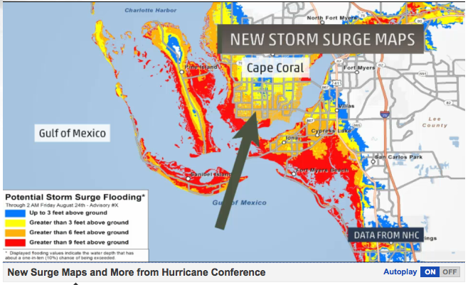
NEW NHC POTENTIAL STORM SURGE MAPS:


This will be a new section on the NHC's website (experimental, will be around for at least 2 years), it will be
updated just like the tracks are (every 6/12 hours, as needed) and will be found on NHC starting June 1st.
xoxo disaster girl


P.F.S. Links for the Curious

December 1, 2013

2013 - The Year Without a 'Cane

Le Sigh, Hurricane Season is Over 
The Last Four Atlantic Hurricane Seasons

Well that was a bit of a disappointment to say the least. The Atlantic 2013 hurricane season began this year with its first storm Tropical Storm Andrea a mere five days after its start. What was forecasted to be a busy season in the TSR review (Tropical Storm Risk Review) was actually well below average but the Atlantic basin was not alone. Even the last below average season the Atlantic saw in 2009 had a whole lot more action than the 2013 season did - 2009 Summary.

This season produced barely a hurricane, with only two forming that either didn't hit US land (Hurricane Ingrid - Mexico), or barely sustained hurricane status for long (Hurricanes Ingrid & Humberto). The tropical storm total rang low this year as well with a total of 13 tropical storms compared to last years 20 tropical storms and 10 hurricanes. Below is a closer look at the ACE data, or the Accumulated Cyclone Energy which uses wind measurements to both measure a storm and an entire season.

2013 World Hurricane Season At A Glance
Atlantic Hurricane Season - ACE - Below Normal - 28% of Average
Pacific Hurricane Season -  MEAN ACE - Below Normal - EST 77% of Average
Global Hurricane Season - ACE - 74% of Average

With no El Nino surface temperatures it has been difficult for forecasters and meteorologists to pin down exactly why this season has slowed down. This years slump also has meteorologists questioning whether or not climate change matters should be factored in at all, with many adding that this level of inactivity has never been seen with ocean conditions as they were this year. In June of 2014 we will usher in the next hurricane season, I have my fingers crossed that it's not as unremarkable as this season was & hope that I can bring the Video/Live Coverage back with some cool stuff.


Until Next Year!

xoxo disaster girl

P.F.S. Links for the Curious

May 12, 2013

2013 Hurricane Season Storm Names!


Hurricane Season is Here!

And below we have our 2013 storm names!


The Atlantic hurricane season begins June 1st and ends November 30th.
The Pacific hurricane season* begins May 15th and ends November 30th.

So which Atlantic Name do you think will achieve hurricane status first?

My money's on Dorian.

xoxo disaster girl

*Pacific hurricane coverage limited to US landfalls and significant storm systems.

August 25, 2012

Gulf Coast Threats: Tropical Storm Isaac Coverage 8/30/2012 18:00

Tropical Depression Isaac Coverage


Tropical  Depression   Isaac
Max Ssd. Winds:   35 MPH
Moving: NNW at 12  MPH
Min. Pressure:  995  MB
Updated:  8/30/2012 18:00


FL Beach At Normal Last Week                           FL Beach 3 Days Before Isaac

Tropical Storm Isaac made landfall in Haiti, barreling Port-Au-Prince as it almost gained hurricane status early Saturday morning. Isaac is forcasted to strenghten into a category 1 hurricane before it hits the Gulf Coast sometime between Monday Evening and Tuesday. Warnings have been issued for much of the gulf coast and Florida panhandle, with  all other warnings and watches issued for Florida being discontinued.

On Saturday, Florida Governor Rick Scott placed the entire state of Florida under a State of Emergency ahead of the storm. Residents in the Keys were asked to evacuate as well as citizens that reside in low lying areas in Southern Florida. Port of Miami is scheduled to close at 7PM on Saturday night, as well as Key West International Airport- several flights from Fort Lauderdale-Hollywood International Airport and Miami International Airport have also been canceled as of midday Saturday. More closures to come soon.

Tropical Storm Isaac has already claimed the lives of at least four people in Haiti as well as one in the Dominican Republic. The Republican National Convention has not been cancelled but activities have been postponed until Tuesday afternoon. Florida Governor Rick Scott has already cancelled all of his activities in   the convention center, as well as the Governors of both Louisiana, and Mississippi.

State of Emergencies have been issued in Louisiana,  Mississippi, Alabama and the Florida panhandle as of Sunday evening. Mandatory evacuations have been ordered for Louisiana, Alabama, and the Florida panhandle- and voluntary evacuations have been issued for Mississippi.

Hurricane Isaac made landfall at the mouth of the Mississippi River at 6:45 PM on August 28th, 2012. It was a category 1 hurricane at impact with wind speeds of 80 MPH +, multiple impacts may be expected. Isaac made a second landfall in Port of Fourchon and 2:15 CDT on August 29th, 2012- 7 years exactly from Hurricane Katrina's impact with Louisiana. At his strongest Isaac was a Category 1 Hurricane with sustained winds of 80 MPH and gusts over 100 MPH.

xoxo disaster girl

August 24, 2012

"Hello Boys, I'm baaaaack!"

 
Alas, we meet again.
It's been a while, hasn't it?
 
Over the last couple of weeks I've been busy hauling my tush across the Eastern Seaboard, from Bergen County New Jersey to the shark attack capital of Florida. Moving a thousand miles away isn't as easy as I thought it would be, but the rewards are by far reaching my expectations. I am now stationed a block from the ocean and luckily, I am just in time for Isaac.
 
I've missed you all so much, most of all I've missed the users who worked with me daily at my Above Top Secret forum during the 2012 Zombie Anotcalypse. Sorry guys, but the hunt had to be abandoned- I can assure you however that it has not been forgotten. Now that I live in the heart of the people-eaters, I am in more of a position to report instead of speculate.
 
Tomorrow morning I will be resuming hurricane monitoring beginning with the threat in the South East, Tropical Storm Isaac. Isaac is forcasted to become a hurricane by the time it rolls by Florida, so hopefully I'll get a show.
 
While The Disaster Caster has returned, I am on a bit of a Hiatus. I am currently working tirelessly to add new features to the site including.. DUN DUN DUN... videos! Yes, you heard (or perhaps read) me correctly- I am taking a stab at failing miserably in front of a camera.
 
While these changes are happening the site will still be at full access to you all and with 50+ articles and an amazing 'Resources' section you should be fully entertained. My hope is to first add video reports/coverage of hurricanes, and later segments on other material (don't want to spoil the surprise.. or perhaps prolong my suffering).
 
This is kind of a big deal for me, because I'm more of a writer than I am a video personality so hopefully I don't suck at it. My ideas and vision for the videos will hopefully pan out as planned and I hope that everyone enjoys the work and research I put into them.
 
I will still be updating on tropical storms and hurricanes that are a threat to US land. If I find time to write and post more articles I will certainly do so, but as of now I am trying to school myself in video editing, etc. Honestly, it'll probably seem like I never even left ;)
 
 
Stay Tuned for Tomorrows Update on Tropical Storm Isaac!
 
xoxo disaster girl 


June 24, 2012

Gulf of Mexico - Tropical Depression Debby

Tropical Depression Debby

Tropical Storm Debby has been confusing weather forecasters and computer models all over the country. Debby, a storm with three separate turning centers has yet to allow a computer model to accurately predict where exactly she will head. I haven't seen a storm like this ever, but I have only been following hurricane season for a couple years now. As of June 25th, tropical storm warnings were issued for the Florida coast. Below is Debby's stats as a storm, which will be updated as updates become available.

  • Tropical storm Debby spawned two tornadoes in central Florida's Highland County, killing one person.
  • High winds associated with this storm closed the Florida Sunshine Skyway Bridge. 
  • On 6/25 Florida declares a state of emergency as Debby begins to soak the land. 
  • Tropical Storm Debby made landfall near Steinhatchee, Florida - 160 miles north of Tampa.
  • So far top rainfall in one area for Debby was recorded at 2 feet in towns south of Tallahassee.
  • Sophoppy FL was among one of the hardest towns hit so far as nearly 60 people phoned police for help finding their houses were completely surrounded by water.
  • The Suwannee River surged more than 25 feet in a day, which leaves it 4 feet above flood level. Another River, the Anclote- was also above flood stages on Tuesday- with water not expected to recede for at least another 48 hours. The Caloosahatche river overflowed as well, the wall separating the land from the water has disappeared entirely.
  • On Tuesday a mandatory evacuation was issued for 2,000+ homes located along the Cotee River, officials had to use boats to get the message out.
  • The storm also killed a manatee who was allegedly tied to a seawall by local residents near Tampa.
  • Tropical Storm Debby was downgraded at 8 PM on 6/26 to a tropical depression, however forecasters reported that it wasn't expected to lose its strength while it was over land.
  • Also, all warnings from the National Hurricane Center have been canceled. Only local flood warnings remain in effect. 
  • Tropical Depression/Storm Debby claimed the lives of three people in Polk, Highlands and Pinellas Counties. 
  • Debby maxed out as a tropical storm with winds of 60+ MPH

Debby
As of 6/28/2012 Debby is no longer a storm,
all warnings have been canceled and her remnants
are now an area of low pressure with a 10% chance of
forming a tropical cyclone within the next 24-48 hours.


xoxo disaster girl

May 27, 2012

May 19, 2012

Atlantic Hurricane Season Sneaks Up On East Coast - 5/22/12 Final Update

Tropical Depression Alberto

The Atlantic hurricane season started almost three weeks before schedule this year, with the average date of the first storm of the season being around the 8th of June. Alberto also took a much different path then we typically see and originated off the coast of South Carolina rather than off the African Coast as seen more commonly in the Atlantic. The storm also made significant strides today going from a low percentage chance of a storm, to a decently organized tropical storm border lining hurricane strengths and pressures in a few hours.

Interesting Facts About Alberto
  • First tropical storm in the Atlantic in 2012, formed 13 days before season officially started
  • Earliest-forming tropical storm in Atlantic since Ana in 2003
  • First time tropical storms formed in both basins before the official start of the East Pacific and Atlantic hurricane season
  • First named storm usually arrives around the 9th of July  (51 days early)
  • First area of interest usually forms by the 8th of June (20 days early)
  • Originated from an area that is not highly common for forming tropical storms
  • 23rd pre-June named storm, only one (Able, 1951) became a major hurricane

As always you can follow here, or use any one of the resources listed in the Resources tab.
Updates will be added as they come in from the NHC.

xoxo disaster girl