Showing posts with label tropical storm warnings. Show all posts

August 24, 2014

Atlantic Tropical Update - Post Tropical Cyclone Cristobal - 8/29 9PM

Post-Tropical Cyclone Cristobal


Hurricane Cristobal - Cat 1
Max Ssd.Winds:  75   MPH  ↓
Moving:   NE   at  44  MPH   ↓
Min  Pressure:   980   MB     ↑
Overview: FINAL  ADVISORY
Last Updated:  8/29/14   9 PM


CURRENT STORM WATCHES & WARNINGS ISSUED:
NONE CURRENTLY ACTIVE


xoxo disaster girl

August 3, 2014

Hawaiian Tropical Update - Hurricane Iselle & Hurricane Julio- 8/9 11PM

HAWAIIAN THREATS

Hurricane Julio


Hurricane Julio - Category 2
Max Ssd.Winds: 100  MPH   ↓
Moving: WNW  at  16  MPH  -
Overview:   LAST  UPDATE  -
Last Updated: 8/9/14  - 11 PM


CURRENT STORM WATCHES & WARNINGS ISSUED:
NO WARNINGS CURRENTLY ACTIVE 


Post Tropical Storm Iselle


Post   Tropical   Storm  Iselle
Max Ssd.Winds:    35  MPH   ↓
Moving: West    at  14  MPH  ↓
Overview:  LAST UPDATE - - -
Last Updated:  8/9/14 -  11 PM


CURRENT STORM WATCHES & WARNINGS ISSUED:
ALL WARNINGS NOW DISCONTINUED.


_______________________________________________________________________________________________


Post Tropical Storm Bertha


Post Tropical Storm Bertha
Max Ssd.Winds:  50   MPH -
Moving:  NE   at   31  MPH ↑
Min Pressure:   1006   MB  ↓
Overview: Now Extratropical 
Last Updated:  8/6/14 - 2 PM


Hurricane Bertha is not currently forecasted to have any US land impacts. Rough waters off the Eastern US seaboard will be expected this week. Bertha strengthened into a Category 1 hurricane between 8/3 & 8/4 2014. As of 8/6 Bertha was categorized as a post tropical storm and was moving out to sea. 8/6 2PM will be the last update for this storm.


xoxo disaster girl

July 1, 2014

Atlantic Tropical Update - Hurricane Arthur - 7/4 11PM Update

Hurricane Arthur


Hurricane Arthur  -  Cat 1
Max Ssd.Winds:  80 MPH -
Moving:  NE  at 28  MPH  ↑
Min Pressure:    976   MB ↓
Overview:  Holding Strong -
Last Updated: 7/4/14  11PM


Tropical Storm Arthur formed in the last couple of days just off the coast of the Eastern coast of Florida. Arthur is currently forecasted to continue up the Eastern of the US and the current five day models show it strengthening to hurricane intensity between Thursday July 3rd and Friday July 4th. Tropical Storm Arthur strengthened to a category one hurricane late Wednesday night. Hurricane Arthur is expected to make a second landfall in Canada. This information will be updated as all necessary information comes in.

CURRENT STORM WATCHES & WARNINGS ISSUED:
NO WARNINGS CURRENTLY ACTIVE


TIMELINE OF EVENTS:
( ACTIVE / DISCONTINUED )

  • 7/2 - Tropical Storm Watches Issued in Florida from Flagler Beach to Port St Lucie
  • 7/2 - Red flags were flown in several States today (Florida, Georgia), other states that will likely be flying red rip current flags will likely be South Carolina, North Carolina, and parts of Virgina in the coming days.
  • 7/2 - Dare County, North Carolina - State of Emergency Declared
  • 7/2 - Hattara's Island, North Carolina - Mandatory Evacuation Starting at 5AM on July 3rd
  • 7/2 - Hyde County, North Carolina -  Voluntary Evacuation Orders Issued
  • 7/3 - Pender County, North Carolina - State of Emergency Declared 
  • 7/3 - Hurricane Watches Issued for Coastal/Island areas in Massachusetts 
  • 7/3 - Several tornado warnings have been issued and continue to be issued
  • 7/3 - Hurricane Arthur made landfall at 11:15 PM at Cape Lookout and Beaufort North Carolina as a Category 2 hurricane with wind speeds of 100 MPH. 
  • 7/4 - Hurricane Arthur moves away from the North Carolina coast, the next area it is expected to directly affect is coastal Rhode Island and Massachusetts areas before moving on to Canada. 
  • 7/4 - All warnings/watches cancelled for North Carolina. Beaches Reopen, damage minimal, no casualties reported.


xoxo disaster girl

May 15, 2014

Hurricane Season Begins! 2014 Storm Names & Season Outlooks / Website Changes

WEBSITE CHANGE NOTE: Hurricane/Tropical Storm coverage has been moved. It now has its own tab listed in the toolbar, and will remain the first tab during hurricane season. Once hurricane season has ended 'The Latest' (other articles) will be reverted back to the first tab. All other articles can still be found under 'The Latest' at any point during the year, or by using the pull down menu located on the right sidebar of this page. Thank you.
TROPICAL OUTLOOKS &


2014 STORM SEASON OUTLOOKS


SPECIAL NOAA NATIONAL HURRICANE CENTER NOTE:

THE NHC WILL BE CHANGING THE LAYOUT OF THEIR STORM TRACKS THIS YEAR. THIS WILL
MAKE THE MAPS LOOK A WHOLE LOT MORE COMPLICATED AND WILL HIGHLIGHT EVEN SMALL
DEVELOPMENTS SO THAT 'FOLKS CAN STAY BETTER PREPARED'. BELOW IS A SAMPLE OF WHAT
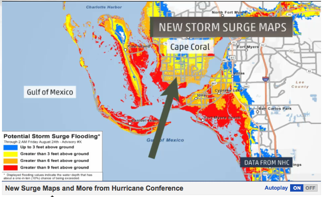
THE NEW NATIONAL HURRICANE CENTER'S MAPS WILL LOOK LIKE STARTING JULY OF THIS YEAR.


NEW NHC POTENTIAL STORM SURGE MAPS:


This will be a new section on the NHC's website (experimental, will be around for at least 2 years), it will be
updated just like the tracks are (every 6/12 hours, as needed) and will be found on NHC starting June 1st.
xoxo disaster girl


P.F.S. Links for the Curious

October 3, 2013

Gulf Threats - Tropical Depression Karen - Updated 10/7 12AM

Tropical Depression Karen

Tropical     Storm     Karen
Max Ssd.  Winds:   30  MPH
Moving: North East at 2 MPH
Min.  Pressure:   1009  MB-
Last Updated: 10/ 07/ 2013
US Land  Impacts:  LA, MS,
AL,  GA,  FL,  - Gulf  Coast

Storm Related Events
-FEMA is doing a "limited recall" of workers in affected areas, over 80% were furloughed in recent government shutdown.
-Mississippi declares State of Emergency in preparation of storm-This storm is expected to make two landfalls, one in Louisiana and another in the Florida Panhandle
-Alabama declares State of Emergency due to likely impact from Karen.
-New Orleans & Louisiana declare State of Emergency ahead of Tropical Storm Karen
-Hurricane watches for coastal cities no longer in effect as of the morning of 10/5.
-Evacuation orders in Louisiana eased as storm loses punch.

All warnings discontinued as Karen dissipates and becomes a remnant low.

xoxo disaster girl

July 8, 2013

Atlantic Tropical Update - Tropical Wave Chantal Moves Over Lesser Antilles - 7/11 AM Update

Tropical Wave Chantal
NOTE: THE ABOVE IMAGE IS FROM 7/9 AND IS NOT NEW
Courtesy of the National Hurricane Center

Tropical     Wave     Chantal
Max Ssd.Winds:  45 MPH↓
Moving: West at 23 MPH↓
Min Pressure: 1012 MB ↑
Last Updated:  7/11/2013

Chantal is currently listed as a tropical wave, I will be keeping an eye on Chantal for possible restrengthening (the storm only slightly weakened, but became very disorganized). Check back tomorrow for more updates!

Major   City   Hit   Timeline
E  Cuba - 7/11  AM / PM
Bahamas -  7/11 PM-AM
SE Florida-7/12 PM-AM
 E Coast FL - 7/12 - 7/14

 Stay tuned!

xoxo disaster girl

August 25, 2012

Gulf Coast Threats: Tropical Storm Isaac Coverage 8/30/2012 18:00

Tropical Depression Isaac Coverage


Tropical  Depression   Isaac
Max Ssd. Winds:   35 MPH
Moving: NNW at 12  MPH
Min. Pressure:  995  MB
Updated:  8/30/2012 18:00


FL Beach At Normal Last Week                           FL Beach 3 Days Before Isaac

Tropical Storm Isaac made landfall in Haiti, barreling Port-Au-Prince as it almost gained hurricane status early Saturday morning. Isaac is forcasted to strenghten into a category 1 hurricane before it hits the Gulf Coast sometime between Monday Evening and Tuesday. Warnings have been issued for much of the gulf coast and Florida panhandle, with  all other warnings and watches issued for Florida being discontinued.

On Saturday, Florida Governor Rick Scott placed the entire state of Florida under a State of Emergency ahead of the storm. Residents in the Keys were asked to evacuate as well as citizens that reside in low lying areas in Southern Florida. Port of Miami is scheduled to close at 7PM on Saturday night, as well as Key West International Airport- several flights from Fort Lauderdale-Hollywood International Airport and Miami International Airport have also been canceled as of midday Saturday. More closures to come soon.

Tropical Storm Isaac has already claimed the lives of at least four people in Haiti as well as one in the Dominican Republic. The Republican National Convention has not been cancelled but activities have been postponed until Tuesday afternoon. Florida Governor Rick Scott has already cancelled all of his activities in   the convention center, as well as the Governors of both Louisiana, and Mississippi.

State of Emergencies have been issued in Louisiana,  Mississippi, Alabama and the Florida panhandle as of Sunday evening. Mandatory evacuations have been ordered for Louisiana, Alabama, and the Florida panhandle- and voluntary evacuations have been issued for Mississippi.

Hurricane Isaac made landfall at the mouth of the Mississippi River at 6:45 PM on August 28th, 2012. It was a category 1 hurricane at impact with wind speeds of 80 MPH +, multiple impacts may be expected. Isaac made a second landfall in Port of Fourchon and 2:15 CDT on August 29th, 2012- 7 years exactly from Hurricane Katrina's impact with Louisiana. At his strongest Isaac was a Category 1 Hurricane with sustained winds of 80 MPH and gusts over 100 MPH.

xoxo disaster girl

June 24, 2012

Gulf of Mexico - Tropical Depression Debby

Tropical Depression Debby

Tropical Storm Debby has been confusing weather forecasters and computer models all over the country. Debby, a storm with three separate turning centers has yet to allow a computer model to accurately predict where exactly she will head. I haven't seen a storm like this ever, but I have only been following hurricane season for a couple years now. As of June 25th, tropical storm warnings were issued for the Florida coast. Below is Debby's stats as a storm, which will be updated as updates become available.

  • Tropical storm Debby spawned two tornadoes in central Florida's Highland County, killing one person.
  • High winds associated with this storm closed the Florida Sunshine Skyway Bridge. 
  • On 6/25 Florida declares a state of emergency as Debby begins to soak the land. 
  • Tropical Storm Debby made landfall near Steinhatchee, Florida - 160 miles north of Tampa.
  • So far top rainfall in one area for Debby was recorded at 2 feet in towns south of Tallahassee.
  • Sophoppy FL was among one of the hardest towns hit so far as nearly 60 people phoned police for help finding their houses were completely surrounded by water.
  • The Suwannee River surged more than 25 feet in a day, which leaves it 4 feet above flood level. Another River, the Anclote- was also above flood stages on Tuesday- with water not expected to recede for at least another 48 hours. The Caloosahatche river overflowed as well, the wall separating the land from the water has disappeared entirely.
  • On Tuesday a mandatory evacuation was issued for 2,000+ homes located along the Cotee River, officials had to use boats to get the message out.
  • The storm also killed a manatee who was allegedly tied to a seawall by local residents near Tampa.
  • Tropical Storm Debby was downgraded at 8 PM on 6/26 to a tropical depression, however forecasters reported that it wasn't expected to lose its strength while it was over land.
  • Also, all warnings from the National Hurricane Center have been canceled. Only local flood warnings remain in effect. 
  • Tropical Depression/Storm Debby claimed the lives of three people in Polk, Highlands and Pinellas Counties. 
  • Debby maxed out as a tropical storm with winds of 60+ MPH

Debby
As of 6/28/2012 Debby is no longer a storm,
all warnings have been canceled and her remnants
are now an area of low pressure with a 10% chance of
forming a tropical cyclone within the next 24-48 hours.


xoxo disaster girl

May 27, 2012

Atlantic Tropical Final Update - Post Tropical Storm Beryl 5/30/2012 17:00

Tropical depression Beryl made landfall as a Tropical Storm at
Jackonville Beach Florida at 12 AM on 5/28/2012
Local Storm Report for Jacksonville Area

- An estimated 24,000 people without power
- First storm to make landfall in May in over 100 years
- Strongest storm in May in over 100 years

xoxo disaster girl

May 19, 2012

Atlantic Hurricane Season Sneaks Up On East Coast - 5/22/12 Final Update

Tropical Depression Alberto

The Atlantic hurricane season started almost three weeks before schedule this year, with the average date of the first storm of the season being around the 8th of June. Alberto also took a much different path then we typically see and originated off the coast of South Carolina rather than off the African Coast as seen more commonly in the Atlantic. The storm also made significant strides today going from a low percentage chance of a storm, to a decently organized tropical storm border lining hurricane strengths and pressures in a few hours.

Interesting Facts About Alberto
  • First tropical storm in the Atlantic in 2012, formed 13 days before season officially started
  • Earliest-forming tropical storm in Atlantic since Ana in 2003
  • First time tropical storms formed in both basins before the official start of the East Pacific and Atlantic hurricane season
  • First named storm usually arrives around the 9th of July  (51 days early)
  • First area of interest usually forms by the 8th of June (20 days early)
  • Originated from an area that is not highly common for forming tropical storms
  • 23rd pre-June named storm, only one (Able, 1951) became a major hurricane

As always you can follow here, or use any one of the resources listed in the Resources tab.
Updates will be added as they come in from the NHC.

xoxo disaster girl