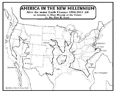
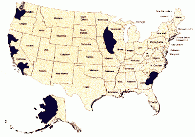
These are the Futurists Maps of the World. I have scoured much of the internet for quite some time now compiling these maps, and I know they are the favorite topic of my readers. This may not be all of them, but from what I found while searching the internet, this is the most you will find in one place- neatly grouped together. I hope you guys enjoy this, and check back in the future because if I find more I will add them!
The Futurist Map's Of America & The World
Also, this cool tool provided by Alex Tingle is awesome! An interactive flood map, based on where you are, that allows you to look at what the land around you would look like with a 60 meter sea level rise!
CLICK HERE FOR THE INTERACTIVE FLOOD MAP
Two questions came to mind when putting this together..
1. Why are the majority of them just the USA? Is that a coincidence?
..and..
2. Why do they all look so eerily similar?
1. Why are the majority of them just the USA? Is that a coincidence?
..and..
2. Why do they all look so eerily similar?
*I do not own any of these images.
*Please comment if you have more information about origins/back stories/unidentified map clarifications, etc!


Likely they all start with relatively the same stats on sea level. With that as a basis anybody with a topological map would be able to say "Sixty meters of water rise in the oceans would make it look like this."
ReplyDeleteWhy the US. I think that's a mixture of self focused Americans and those in other countries who are watching for super powers to fall and those who want to see those upstart yankees get what's commin to em for bein so uppity. lol.
It likely doesn't hurt that The US is a huge land mass, good for the example, they are a huge political force (good or bad) and whenthey face this it will effect those around them, they are a huge economic (world economies react to it) force as seen in the recent economic crisis. And large amounts of trade and relief effort come from the US.
With wide scale continental changes doing this sort of thing to the US it will change the world: physically, politically, economically, environmentally and culturally.
Sound Amerocentric I'm sure but thankfully it looks like recent events are changing that system and this thought process is becoming outmoded.
Hi There DG,
ReplyDeleteVery nice collection you have here! Thanks for putting them together in one place.
Spotted a bit of errata: it is "Gordon Michael" Scallion, rather than "George" Scallion.
Cheers,
A. Nonymous
Great Maps! I'm Pro-Global Warming, Nuke the Poles! (Seriously, anything to shake things up.)
ReplyDeleteThe idea of solar power has been around for some time, but it’s never been considered a practical means for satisfying the world’s energy needs. But as better methods for capturing and converting the sun’s rays into usable energy are developed, solar power is becoming widely adopted crossways many countries. solar power.
ReplyDeleteHere’s a look at a few countries making the most use of solar power.
"Likely they all start with relatively the same stats on sea level. With that as a basis anybody with a topological map would be able to say "Sixty meters of water rise in the oceans would make it look like this."
ReplyDeleteWhy the US. I think that's a mixture of self focused Americans and those in other countries who are watching for super powers to fall and those who want to see those upstart yankees get what's commin to em for bein so uppity. lol."
Too much wishful thinking on your part. Apparently, it seems easier to ignore the fact the whole world is going to suffer. Most of Europe isn't going to exist! lol
i like your collection of maps. the delusion of change, still a good joke today and, tomorrow....i drive for hours trying to get abducted by aliens. i buried magnets in my lawn in hopes of attracting lightning. i pray for comets through my roof. a stray transport truck tire through my windshield on the drive in to work. nothing. i look at the maps and i have to laugh.
ReplyDelete"i like your collection of maps. the delusion of change, still a good joke today and, tomorrow....i drive for hours trying to get abducted by aliens. i buried magnets in my lawn in hopes of attracting lightning. i pray for comets through my roof. a stray transport truck tire through my windshield on the drive in to work. nothing. i look at the maps and i have to laugh."
DeletePoetic.
The Gordon-Michael Scallion info been here awhile, one set I do not see is anything from Ruth Mongomery, I believe she had some contributions for future maps also. This is Very awesome as a collected data set! Thank you for putting the work in to do this. I have been looking for information on the 'ley lines' of the earth also, the 'magnetic/electrical' corridors that run both vertically and horizontally on our magnetic plane earth. The interesting thing I have heard, is that the governments - at least two of them - England and America "happen" to have "coincidentally" built Buckingham Palace and the Washington D.C. Capital of the USA over places where the 'ley lines' intersect each other. How Amazing is That? Makes you wonder what kind of 'fields' are 'generated ' at those 'crossing places'. It would be very interesting to see how the ley lines stack up with the land masses, both before and after maps! I sincerely hope you can find info on those things and get them posted here. Again, sincere thanks for the work you have put in here. Quite interesting to see them collected together in one place!
ReplyDeleteThank for for the tip I will definitely look into Ruth Montgomery- if you have any direct links to her maps it would be greatly appreciated!
DeleteI will think about adding ley line maps to the site as well as I do think that it would be a nice add :)
Thank you for stopping by and writing! I love comments like these that offer information to expand on what I already have.
what about the oil plants in the oceans? Dont u think that would be a problem? Look at bp in the gulf and this is a fully function society and look how long it took to fix the problem. Imagine this all over the world . And dont forget the power plants that sit on the coastlines n every country. No more clean oceans. Population reduction for real.
ReplyDeletewe live at 1500 above sea level, but most maps wiped us out.
ReplyDeleteBut 60 meters of water is 130ish feet, even a colossal earth quake would be hard pressed to remove the remaining 1430 feet. If it did, I think we would have other geothermal activity like the super volcano at yellowstone, with continent destroying ash clouds.
The Minoan/Crete eruption in 2,500 BC left 100 foot thick ash and multiple 20 meter tsunamis. but that's a 1 in 40k year event, so I am calling BS on these maps within our lifetimes. Also calling BS on man made global warming. I do think we need to clean up our act, shanghai being the poster child for how evil fascism is, corporate collusion with the state to promote corporate goals rather than goals to better the people. this modern fascism is the second major organized human evil, right behind the whole central banking/fiat currency/ fractional reserve/ planned 2% inflation thing. The new system needs to be matals backed currency, corporations may exist (otherwise its like grasping the wind) but all corps must be ESOP, with 66% employee owned voting stock. of course outside capital injection is necessary to make a business venture become solid, but detach money from power. corps may not lobby, vote or have any human type rights. go ahead and invest for profit, but that profit does not grant any corporate/politcal leverage. educate the masses that civic duty comes with liberty or you get sociopaths in charge.
I agree with you about all the financial stuff, however I do think you will find this article interesting regarding the mega-tsunami's.
Deletehttp://www.disaster-girl.com/2012/04/current-threats-megatsunamis-theyre-not.html
all this is nice....and seemingly based on current elevations. But it doesn't take into account the results of nuclear reactors being put under water...like Fukashima. While I might think I am safe and smug at 7,500 ft and in the dry on all maps.....the reality is.....the nuclear fallout from the sunken nuclear plants will still wipe us all out....even if only three or four go under. And most are in a low elevation area, and close to water for cooling.
ReplyDeleteI love the map collection, but wanted to let you know that on the JOHN R. MOORE SUPPOSED NAVY APPROVED MAP, that Little Rock is more centered in Arkansas and the state abbreviation is AR. You show AK and that is for Alaska.
ReplyDeleteOne reason the maps may be America centric is that it may reflect better topographic data.
ReplyDeleteThis comment has been removed by the author.
ReplyDeleteGordon Michael Scallion and Al Bielek are the two sources that actually gave credibility to this phenomenon because the two of them drew the same maps. Al Bielek was the source that legitimized it for the US Navy. A a crew member of the USS Eldridge in the Philadelphia Experiment was the sole survivor to the ill fated crew. The testimony he gave was far more than anything imaginable at the time.
ReplyDeleteAs a result of both the Philadelphia Experiment and Al Bielek's testimony, senior US leadership and scientists used the prophecy to create the current Global Warming crisis and panic presently running amok in scientific and political circles. However, this Global Warming panic is a hoax to distract the public from truths regarding these environmental changes by placing the blame on human activities. The real truth is far deeper and more disturbing than I can mention, because it involves a secret war being waged inside the US between the political, scientific and the military industrial complex over power. Nonetheless, the powers that be can't do anything about these changes. So, they hope to distract the people long enough to allow a sufficient culling of the human population.
That is why Obama is migrating illegally millions of Muslims from Africa and the Middle East into the US in the hopes a saving the doomed culture.
maps are nice but they are useless as they are too small to see much detail.
ReplyDeleteThis comment has been removed by the author.
ReplyDeleteThis comment has been removed by the author.
ReplyDelete2017 has well been known to be the end of days as we know it, the entire west coast (ring of fire quake zone) will sink california and nevada also utah, this is in accord with the mormon temple prophecy of the ancient ones, many masses of mormons are now moving to the upper dakotas
ReplyDelete