

PACIFIC HURRICANE SEASON RUNS FROM MAY 15TH UNTIL NOVEMBER 30TH.
ATLANTIC HURRICANE SEASON RUNS FROM JUNE 1ST UNTIL NOVEMBER 30TH.
STORM #5
Post-Tropical Cyclone Cristobal

Hurricane Cristobal - Cat 1
Max Ssd.Winds: 75 MPH ↓
Moving: NE at 44 MPH ↓
Min Pressure: 980 MB ↑
Overview: FINAL ADVISORY
Last Updated: 8/29/14 9 PM
CURRENT STORM WATCHES & WARNINGS ISSUED:
NONE CURRENTLY ACTIVE
xoxo disaster girl
Hurricane Julio

Hurricane Julio - Category 2
Max Ssd.Winds: 100 MPH ↓
Moving: WNW at 16 MPH -
Overview: LAST UPDATE -
Last Updated: 8/9/14 - 11 PM
CURRENT STORM WATCHES & WARNINGS ISSUED:
NO WARNINGS CURRENTLY ACTIVE
STORM #3
Post Tropical Storm Iselle

Post Tropical Storm Iselle
Max Ssd.Winds: 35 MPH ↓
Moving: West at 14 MPH ↓
Overview: LAST UPDATE - - -
Last Updated: 8/9/14 - 12 PM
CURRENT STORM WATCHES & WARNINGS ISSUED:
ALL WARNINGS NOW DISCONTINUED.
STORM #2
Post Tropical Storm Bertha

Post Tropical Storm Bertha
Max Ssd.Winds: 50 MPH -
Moving: NE at 31 MPH ↑
Min Pressure: 1006 MB ↓
Overview: Now Extratropical
Last Updated: 8/6/14 - 2 PM
Hurricane Bertha is not currently forecasted to have any US land impacts. Rough waters off the Eastern US seaboard will be expected this week. Bertha strengthened into a Category 1 hurricane between 8/3 & 8/4 2014. As of 8/6 Bertha was categorized as a post tropical storm and was moving out to sea. 8/6 2PM will be the last update for this storm.
CURRENT STORM WATCHES & WARNINGS ISSUED:
NO WARNINGS CURRENTLY ACTIVE
xoxo disaster girl
STORM #1
Hurricane Arthur

Hurricane Arthur - Cat 1
Max Ssd.Winds: 80 MPH -
Moving: NE at 28 MPH ↑
Min Pressure: 976 MB ↓
Overview: Holding Strong -
Last Updated: 7/4/14 11PM
Tropical Storm Arthur formed in the last couple of days just off the coast of the Eastern coast of Florida. Arthur is currently forecasted to continue up the Eastern of the US and the current five day models show it strengthening to hurricane intensity between Thursday July 3rd and Friday July 4th. Tropical Storm Arthur strengthened to a category one hurricane late Wednesday night. Hurricane Arthur is expected to make a second landfall in Canada. This information will be updated as all necessary information comes in.
CURRENT STORM WATCHES & WARNINGS ISSUED:

NO WARNINGS CURRENTLY ACTIVE
TIMELINE OF EVENTS:
( ACTIVE / DISCONTINUED )
- 7/2 - Tropical Storm Watches Issued in Florida from Flagler Beach to Port St Lucie
- 7/2 - Red flags were flown in several States today (Florida, Georgia), other states that will likely be flying red rip current flags will likely be South Carolina, North Carolina, and parts of Virgina in the coming days.
- 7/2 - Dare County, North Carolina - State of Emergency Declared
- 7/2 - Hattara's Island, North Carolina - Mandatory Evacuation Starting at 5AM on July 3rd
- 7/2 - Hyde County, North Carolina - Voluntary Evacuation Orders Issued
- 7/3 - Pender County, North Carolina - State of Emergency Declared
- 7/3 - Hurricane Watches Issued for Coastal/Island areas in Massachusetts
- 7/3 - Several tornado warnings have been issued and continue to be issued
- 7/3 - Hurricane Arthur made landfall at 11:15 PM at Cape Lookout and Beaufort North Carolina as a Category 2 hurricane with wind speeds of 100 MPH.
- 7/4 - Hurricane Arthur moves away from the North Carolina coast, the next area it is expected to directly affect is coastal Rhode Island and Massachusetts areas before moving on to Canada.
- 7/4 - All warnings/watches cancelled for North Carolina. Beaches Reopen, damage minimal, no casualties reported.
xoxo disaster girl
2014 TROPICAL OUTLOOKS / NAMES
WEBSITE CHANGE NOTE: Hurricane/Tropical Storm coverage has been moved. It now has its own tab listed in the toolbar, and will remain the first tab during hurricane season. Once hurricane season has ended 'The Latest' (other articles) will be reverted back to the first tab. All other articles can still be found under 'The Latest' at any point during the year, or by using the pull down menu located on the right sidebar of this page. Thank you.

2014 STORM SEASON OUTLOOKS
Colorado State University Tropical Outlook Report - BELOW AVERAGE
The Weather Channel Tropical Outlook Report - BELOW AVERAGE
Tropical Storm Risk 2014 Tropical Outlook Report - BELOW AVERAGE
Wunderground.com 2014 Tropical Outlook Report - BELOW AVERAGE
CPC / NWS Weekly 2014 Tropical Outlook Report - BELOW AVERAGE
N.O.A.A. / N.H.C. 2014 Tropical Outlook Report - BELOW / AVERAGE

Wunderground.com 2014 Tropical Outlook Report - BELOW AVERAGE
CPC / NWS Weekly 2014 Tropical Outlook Report - BELOW AVERAGE
N.O.A.A. / N.H.C. 2014 Tropical Outlook Report - BELOW / AVERAGE

SPECIAL NOAA NATIONAL HURRICANE CENTER NOTE:
THE NHC WILL BE CHANGING THE LAYOUT OF THEIR STORM TRACKS THIS YEAR. THIS WILL
MAKE THE MAPS LOOK A WHOLE LOT MORE COMPLICATED AND WILL HIGHLIGHT EVEN SMALL
DEVELOPMENTS SO THAT 'FOLKS CAN STAY BETTER PREPARED'. BELOW IS A SAMPLE OF WHAT
THE NEW NATIONAL HURRICANE CENTER'S MAPS WILL LOOK LIKE STARTING JULY OF THIS YEAR.

NEW NHC POTENTIAL STORM SURGE MAPS:
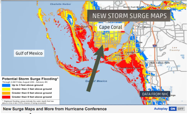
This will be a new section on the NHC's website (experimental, will be around for at least 2 years), it will be
updated just like the tracks are (every 6/12 hours, as needed) and will be found on NHC starting June 1st.
xoxo disaster girl
I voted whatta I get? :)
ReplyDeleteNice website D-G
---Juggernog