Showing posts with label disasters. Show all posts

August 30, 2014

Abandoned by the World - Apocalypse Now Photo Series - Part 5

Apocalypse Now

Previous Segments of the Apocalypse Now Photo Series 


About a year ago I discovered Reddit and as any good Redditor will tell you- I've lost so much time because of it. So much time, gone. The wealth of information on reddit is incredible, and the daunting need to see it all is virtually insatiable.  I am constantly finding new favorites on the site, but my two favorites will always be r/ShowerThoughts and r/AbandonedPorn. Before I found r/AbandonedPorn I used to have to scour the interwebs for new pictures for this photo series, but now.. I'm drowning in them. Now Reddit has this thing about Buzzfeed always stealing their content for articles (I've seen the picture, Buzzfeed.) so I've decided to fully admit my 'borrowing'. These photos ( & the forum itself) are amazing, and need to be seen by the world. For those of you who haven't visited reddit yet.. I'm sorry. You'll understand later.

So once again let's look at some more abandoned places of the world, some near and some far but all equally as breathtaking. If you have an abandoned place in your area, or know of a cool location please feel free to submit via the contact tab above. Below are five more places that the world has forgotten but r/AbandonedPorn has found, some recent- some very old. You can look for Part 6 of the Apocalypse Now Photo Series in early fall of this year.


Abandoned Mine in the Ural Mountains, Russia


Deserted Movie Set in Alabama used to film 'Big Fish'
 Reddit Thread on r/AbandonedPorn


The skeletal remains of a sugar barrons grand mansion, torched during WWII in the Philippines.


Blue Spiral Staircase - Abandoned European Castle - Location Unknown


The Haunted Miranda Castle in Belgium


xoxo disaster girl
 u/disaster_girl

July 10, 2014

Disaster Kit Recommendations - Deep Breaths & Don't Forgets

Disaster Girl's Disaster Recommendations
 Deep Breaths & Don't Forgets
For more please see: previous disaster kit articles.
  
There are so many things to be thought of during moments of disaster, and often times you don't have much time to think about what to do. In situations where you can look back and obviously see that seconds were a deciding factor in a time of crisis, it's helpful to put the effort in before something actually does happen. The world's militaries, schools, and business do it- and you should really conduct drills and practice runs before a disaster too. Here's a list of things commonly forgotten during disaster and times of crisis:


DEEP BREATH
I'll keep this one short because you're probably tired of hearing it, but you really do need to stay calm. Someone panicking and screaming at the top of their lungs in an erratic manner while crying, flailing, and generally acting like a temper tantrum prone child never helped anyone, ever. You can practice this in your everyday life. While it seems minuscule learning to control your actions in mini 'disasters' whether it be someone getting injured unexpectedly or roadside flat in the middle of a thunderstorm it will begin to condition your brain into going into 'fight' mode rather than 'flight' mode. It will help you make better decisions, and think more clearly in situations it can difficult to think in.

FILL BATHTUBS & OTHER CONTAINERS
This is useful in most disaster situations. A bathtub can hold a lot of water which can be used for various things in the event that the water does go off. You can flush a toilet with no power, as long as you have water. If the water goes out for a week a family of three will need around 65 gallons of water just for drinking. Fill everything you can fill, and use the water purification methods listed here for drinking water.

SHUTTING OFF UTILITIES
Sure, we'd all like to ride through a hurricane with the TV on, while making some food on the stove with plans of a hot shower in the mix. While doing all three may seem 'moronic' its fairly common for people to do at least one or two of these things during a disaster. In disaster situations that have slow escalations (I.E. hurricane with a week heads up, severe storms, blizzards) and even ones that happen abruptly (I.E. earthquakes, mudslides, etc) it is important to shut your water, electricity, and gas off- especially when evacuating. While these utilities are pretty safe on their own, mixed with a disaster they can cause more problems than the conveniences they offer.

MONEY & BARTERING
If the power goes out, the credit card machines do too. And if the apocalypse ever does end up happening, having extras of things people may need will be quite handy. You need to have money (preferably in smaller bills & different forms- you don't want to end up paying fifty bucks or a whole gold coin for a loaf of bread), lots of change/coins, and stuff that you're able to barter with (several small bottles of high grade alcohol come to mind). Also, never keep everything together- if you get robbed or even lose something you don't want to lose it all at once.

EXTRA UNDERWEAR
Do I need to go into detail about why this may be useful? You answered 'No.' right?
But I'd be willing to wager that you didn't have any in your disaster kit.

IMPORTANT PERSONAL INFORMATION
Extended family members names, addresses, phone numbers- laminated on a card is incredibly useful. You should have your immediate family's birth certificates, social security cards, IDs, list of credit cards, the deed to the house, your will, any court agreements, all of your car information, and really anything of great importance in a waterproof envelop as well. Primary physicians info, lists of health problems and/or medications taken are also great adds.

THE USEFULNESS OF A PORTABLE TOILET


Luggable Loo
$28.95

Because, when it comes down to it- no one wants to use the bushes.


A GOOD PAIR OF BROKEN IN SHOES
For all the miles you may have to walk. If your car tire gets a flat. If you can't get to the highway because the traffic is at a standstill. For the moments all you can do is run, and just keep running. Oh dear, I sound like a Nike commercial. Those shoes may be the only ones you have for a while so choose wisely. I'm inclined to recommend a skating sneaker brand, as they are so heavily padded.

DISPOSABLE WATERPROOF CAMERAS
The power may go out and your phone battery may die, and in the aftermath of a disaster a digital camera may not be as handy as you would like it to be. You should always have at least one disposable waterproof camera in your disaster kit. You may need to take pictures of the damage afterwards of your house, car, street, etc for insurance and documentation purposes.

COMMUNICATION / SAFE & WELL LIST


If you have internet access after a disaster you can report that you're safe to the American Red Cross Safe & Well List. Alternatively you should also have one extended family member who doesn't live in your geographical region act as a outlet for notifying the rest of the family of your well being. Always remember that during a disaster you will have better luck sending out a text message rather than making a phone call.

_________________________________________________________________________
 * * * * *

I'm totally starting to get why so many 'Preppers' devote entire basements, and in some cases even separate houses to storing all this stuff. The list of what you may need is really never ending, with new tools being made or discovered daily. It's the 'hobby' that keeps on giving.


xoxo disaster girl 
 

June 1, 2014

5 More Abandoned by the World - Apocalypse Now Photo Series - Part 4

Apocalypse Now

I was having so much 'fun' finding places that I got a little ahead of myself with this series and decided to continue it way earlier than expected, for the previous parts to the Apocalypse Now Photo Series please visit the following links [ Part 1 | Part 2 | Part 3 ]. The ruins of yesteryear exist everywhere in the world, and sometimes they're even in your own backyard. If you have an abandoned place in your area, or know of a cool one please feel free to submit via the contact tab above. Below are five more places that the world has forgotten about, some recent- some very old. You can look for Part 5 of the Apocalypse Now Photo Series in late summer of this year.


Pollepel Island, Hudson River, New York

Six Flags, New Orleans, Louisiana

Hashima Island, Nagasaki Prefecture, Japan

Roll Acres Mall, Akron Ohio

Ross Island, Andaman and Nicobar Islands


xoxo disaster girl

December 29, 2013

State of the World 2013 - The Anti-Apocalypse

The State of the World Report
2013
The Anti-Apocalypse

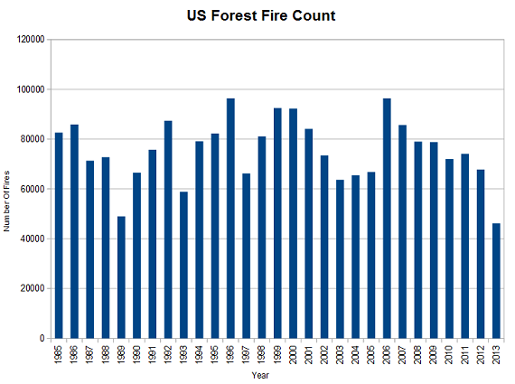
After a rather lackluster global hurricane season this year, I decided to look into how the rest of the worlds disasters fared statistically in 2013. Nearly every kind of disaster saw a decrease in activity this year, with some even having some historical significance. [Note: The last time both the Atlantic and Pacific hurricane seasons both averaged below normal was 1977] Other notables include: Lowest Tornado Numbers in US since 2005 and the Lowest Forest Fire Numbers since 1989. Most totals rang in lower with some exceptions: Solar and Volcanic Activity still saw a small uptick recently. While the statistics show that natural disasters are on a decline, there were still many tragic disasters that did occur this year. After the 'Statistics' section of this report is a look at the worst disaster of 2013. 

Statistics 2013
Global Earthquake Total - Yearly Comparison


Global Hurricane ACE - Atlantic/Pacific Comparison


Global Tornado Totals - Euro/ US Comparison


US Forest Fires Rates


 Global Temperature Statistics


US Flood/Drought Yearly Comparison


Solar Activity in 2013

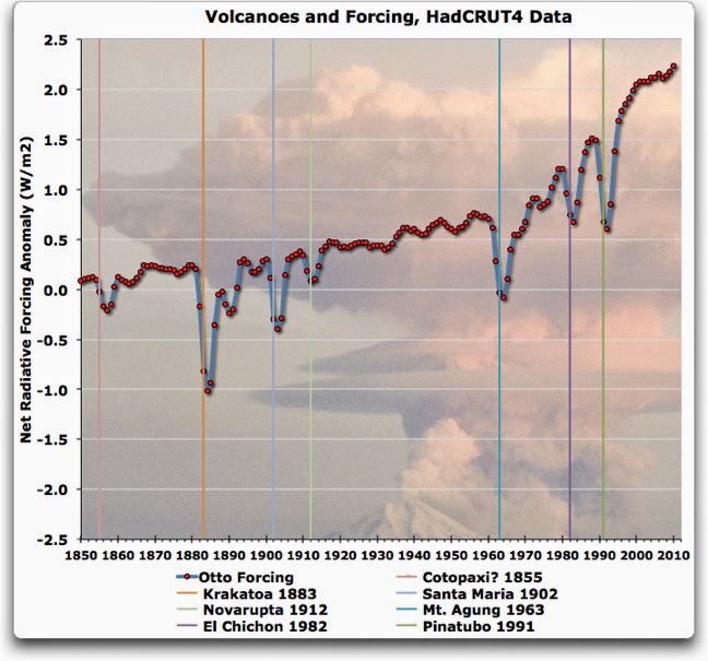
Volcanic Activity At A Glance
*An up to date volcano eruption chart was unavailable, please note this only goes until 2010.


 The Worst Disaster of 2013
 Typhoon Haiyan

Typhoon Haiyan was a pacific 'hurricane' that effected several countries (Micronesia, the Philippines, Vietnam, and Southern China, Taiwan) in November of this year for 8 days . It is thought to be one of the strongest hurricanes that has ever hit land, but as every country measures storms differently it is hard to get a consensus on that matter as it ties closely with several other storms. The preliminary damage estimates caused by Haiyan exceed 1.5 Billion US dollars, although it is still fairly early for those estimates to be entirely accurate. The death toll caused by Haiyan is currently over 6,100+ people and rising, with over 1,500 people still missing. The highest winds measured during the storm were as followed: 1 Min Sustained - 195 MPH, 10 Min Sustained - 145 MPH. The lowest recorded internal pressure of Haiyan is estimated to be around 895 MB at peak intensity. Just under 200 Millions Dollars was raised from countries worldwide to help support relief efforts, although this figure does not include charity donations, etc.

xoxo disaster girl

P.F.S. Links for the Curious
2013 Earthquakes At-A-Glance
2013 Atlantic Season At-A-Glance
ACE Total Archives
DG TDC - The Year Without a 'Cane
2013 Tornadoes At-A-Glance
US Forest Fire Statistics
US 2013 State of the Climate Report
Typhoon Haiyan Wiki
 

August 26, 2013

Hungry Earth Chronicles - What the Earth Ate This Month

What the Earth Ate this Month

                              08/01/2013 - Cottondale, Alabama - Sinkhole Closes Only Road In Town
                              08/04/2013 - Sharon Springs, Kansas - 200 FT Sinkhole Opens Up
                              08/05/2013 - Miami Beach, Florida - Sinkhole Nearly Swallows Car
                              08/07/2013 - Kingston, New York - Sinkhole Swallows Section of Street
                              08/09/2013 - Pittsburg, Pennsylvania - Sinkhole Swallows Intersection
                              08/10/2013 - Montgomery Township, Pennsylvania - Sinkhole Opens Up In Pond
                              08/11/2013 - Fort Drum, New York - Sinkhole Found in Residents Backyard
                              08/11/2013 - Clermont, FloridaSinkhole Swallows Part of Resort
                              08/13/2013 - Niles, Massachusetts - Sinkhole Opens Up Street
                              08/13/2013 - Simi Valley, California - Sinkhole Swallows Up Intersection 
                              08/14/2013 - Butte-Silver Bow County, Montana - Sinkhole Opens Up in Mans Backyard
                              08/15/2013 - St. Genevieve, MissouriCar Falls Into Sinkhole, Trapping Woman 
                              08/15/2013 - Granby, Massachusetts -  Sinkhole Collapses Yet Another Street
                              08/19/2013 - Gulfport, Mississippi - Sinkhole Collapses Street
                              08/19/2013 - Palm Desert, California - Sinkhole Traps a Car on Cook Street
                              08/20/2013 - Elizabeth, New Jersey - Sinkhole Closes Two Lanes on Highway
                              08/20/2013 - Clarksville, Tennessee - Sinkhole Swallows Highway Lane
                              08/20/2013 - Ocala, FloridaSinkhole Swallows 5 Acre Lake
                              08/21/2013 - Bayou Corn - Louisiana - 1 Year Old Sinkhole Swallows Some More Trees
                              08/22/2013 - Hellam Township, Pennsylvania - Two Sinkholes Discovered on Route 30 W
                              08/23/2013 - Dade City, Florida - 30 FT Wide Sinkhole Swallows Road
                              08/23/2013 - Truckee, California - 8 FT Sinkhole Swallows Highway
                              08/24/2013 - Madawaska, Maine Truck Falls into Sinkhole

The Science Behind Sinkholes
 

Are you in a sinkhole prone area?
Find Out Below!

Courtesy of USGS Water-Science School


Gaia's been awful hungry this month.
xoxo disaster girl

P.F.S. Links For The Curious
 

February 4, 2012

Apocalyptic Wallpapers - Get Your Desktop 2012 Ready!

Here are some apocalyptic wallpapers to
help you guys get your desktops 2012 ready* :)

via Presidia Creative, click the link for more!

*These wallpapers will not work following a CME or EMP

xoxo disaster girl

February 3, 2012

Origins of Conspiracy - The Annunaki

In the past couple of weeks with my conspiracy research, my daily glances at the weird news of the world, and the books I have been reading heavily weighing on my mind- I’ve been asking myself many questions. What if it all could be tied neatly with a bow? What if there was a theory that existed that was, in its entirety, the mother of every major conspiracy theory out there? What if all the conspiracies of the world rooted back to one distinct event? Is that even possible? It really is a fascinating thought, that any conspiracy- no matter how obscure or largely random it may be could possibly be traced back to a much more finite conspiracy.

First let’s start by figuring out the general categories that all conspiracies seem to fall under:
1. World Domination – New World Order
2. Aliens / Rouge ‘Alien’ Planets / ‘All Knowing Beings’
3. Theology / Philosophy / Metaphysics / Origins-Prophecies of Humanity
4. Fragile Earth / Fragile Space / Fragile Universe
5. Parallel Universes / Paranormal Activity
6. Technology / Weaponry / Fringe Science / Geo-Engineering

Didn’t think it would only be six did you? The fact is that almost all conspiracies can be grouped to a larger, more general area of conspiracy. Here are a few examples for each category:

1. 9-11 / One World Currency / New World Order / Illuminati / The One Percent / Global Economy Collapses / False Flags
2. UFO’s / Strange Events / Sky-Earth-Space Anomalies / Nibiru / NEO’s / Crop Circles / Ancient References
3. Bible Mistranslations / Language / Vatican Illuminati / Prophets / Anti-Christ / Levitation / Alchemy / Energy
4. Doomsdays / 2012 Maya Apocalypse / Center of the Universe / Asteroid Impact / Climate Change
5. Hauntings / Alternate Realities / The Bermuda Triangle / Magic / Superior Brain Functions
6. Tech Origins / Secret Tech / Weather Control / Anti-Gravity Propulsion / Earthquake Machines / Particle Accelerators

Could those six really be combined to just one? … Maybe.


Meet the Annunaki, They may have had a much larger influence in our being than you’d like to admit.


"DON'T WATCH THIS FILM" - Annunaki Illuminati Documentary

Could it really be that simple? Could everything we know, everything we question, everything we do not understand- just be the human flaw of constantly over-analyzing things... are we just ignoring the big picture? Preoccupying ourselves with all the mind numbing details..?

To Be Continued..
xoxo
disaster girl


P.F.S. Links for the Curious
Zecharhia Sitchin's The 12th Planet

July 3, 2011

The Information Age Facade

The reality of reality is frightening. They will only tell you what they are comfortable with you knowing; and if you don't know who 'they' are, than hit the back button- because starting here is not an option. If you are not already questioning everything you see and hear, than you are not fully living - and honestly... You have a lot of work to do. It's nearly impossible for anyone, myself included, to be one hundred percent truthful- as we all have a hidden agenda, at times that even we are unaware of. So how do you even find the truth? Is it even possible? Is there anyone out there that can say anything without inserting some type of personal inclination in it? I highly doubt it. Mainstream media was designed with the sole purpose of keeping you busy- wrapped up in a world of biased, never ending grapevines that fuel the continuation of the oblivious masses.

Does it upset you that you know NOTHING? Does it upset you that even in thinking you know something, that you in fact know... nothing? Knowledge itself is so arbitrary that frankly it's sickening. It's a never ending cycle of dogma. How can we possibly believe anything when it’s almost always attaching to some ideology? How can I even believe in what I am writing right now? Certainly I am reinforcing some deep seeded personal agenda unbeknownst to me. By the way, please bear with me as this is becoming increasingly more backbreaking the longer I write this. I am having trouble finding any motivation other than stroking my own ego- What a wonderful ulterior motive, sigh.

Anyway, I've been out of the disaster caster for some time now, disasters have been slightly sidelined so that I could put more focus on philosophy and ancient history. As 2012 prophecies start to rear their ugly heads, I am still trying to find the elusive- a conclusive reason for it all. This attempt is.. unfulfilling and agitating; and although I have no problem admitting that I'm definitely not of the intellect level needed to figure out such mysteries- I cannot help but try. In these attempts to uncover some great, mystical finding- I have found nothing other than misinformation. The problem I'm having is that it isn't localized, it's worldwide. Almost as though everyone was working together in some sort of under the radar endeavor to not just keep us oblivious, but to completely blind us. Scary thought- but then again, everything's scary nowadays.

Mainstream media has made a decision to remain silent on almost all of the important issues. Blinding you with weddings, trials, reality shows, and scandals, you continue to live in the dark. I bet you even watch your local news every night so you "know what's going on in the world", HA! Such naivety. I can think of many things that are/have/will have devastating effects on humanity, earth, and the collective unconscious, yet mainstream media outlets avoid them as if talking/writing/reporting about them is exposing oneself to the black plague.

In my quest for a panoramic view of the world's actual current event, I've been funneling my time towards alternative media sites such as Infowars and ATS, which although extremely helpful, provide only a framework to fully understanding what is truly going on. Recently, I came across an interesting article that listed some of the top things news networks have choose to ignore in the last couple of months. Interestingly enough- when read in order sound more like the plot of a disaster flick than an actual occurrence.

Excerpt from The End of The American Dream Article*

"The following are 12 things that the mainstream media is being strangely quiet about right now....

#1 The crisis at the Fort Calhoun nuclear facility in Nebraska has received almost no attention in the national mainstream media.
Back on June 7th, there was a fire at Fort Calhoun. The official story is that the fire was in an electrical switchgear room at the plant. The facility lost power to a pump that cools the spent fuel pool for approximately 90 minutes. According to the Omaha Public Power District, the fire was quickly extinguished and no radioactive material was released.
The following sequence of events is directly from the Omaha Public Power District website....

• There was no such imminent danger with the Fort Calhoun Station spent-fuel pool.
• Due to a fire in an electrical switchgear room at FCS on the morning of June 7, the plant temporarily lost power to a pump that cools the spent-fuel pool.
• The fire-suppression system in that switchgear room operated as designed, extinguishing the fire quickly.
• FCS plant operators switched the spent-fuel pool cooling system to an installed backup pump about 90 minutes after the loss of power.
• During the interruption of cooling, temperature of the pool increased a few degrees, but the pool was never in danger of boiling.
• Due to this situation, FCS declared an Alert at about 9:40 a.m. on June 7.
• An alert is the second-least-serious of four emergency classifications established by the Nuclear Regulatory Commission.
• At about 1:15 p.m. on June 7, FCS operators declared they had taken all appropriate measures to safely return to the previously declared Notification of Unusual Event emergency classification. (See first item above.)

But the crisis at Fort Calhoun is not over. Right now, the nuclear facility at Fort Calhoun is essentially an island. It is surrounded by rising flood waters from the Missouri River.

Officials claim that there is no danger and that they are prepared for the river to rise another ten feet.

The Cooper Nuclear Station in Brownville, Nebraska is also being threatened by rising flood waters. A "Notification of Unusual Event" was declared at Cooper Nuclear Station this morning at 4:02. This notification was issued because the Missouri River's water level reached 42.5 feet.

Right now the facility is operating normally and officials don't expect a crisis.

But considering what has been going on at Fukushima, it would be nice if we could have gotten a lot more coverage of these events by the mainstream media.


#2 Most Americans are aware that the U.S. is involved in wars in Iraq, Afghanistan and Libya. However, the truth is that the U.S. military is also regularly bombing Yemen and parts of Pakistan. If you count the countries where the U.S. has special forces and/or covert operatives on the ground, the U.S. is probably "active" in more countries in the Middle East than it is not. Now there are even persistent rumors that U.S. ground units are being prepared to go into Libya. Are we watching the early stages of World War 3 unfold before our eyes in slow motion?


#3 The crisis at Fukushima continues to get worse. Arnold Gundersen, a former nuclear industry senior vice president, recently made the following statement about the Fukushima disaster....
"Fukushima is the biggest industrial catastrophe in the history of mankind"
TEPCO has finally admitted that this disaster has released more radioactive material into the environment than Chernobyl did. That makes Fukushima the worst nuclear disaster of all time, and it is far from over.
Massive amounts of water are being poured into the spent fuel pools in order to keep them cool. This is creating "hundreds of thousands of tons of highly radioactive sea water" that has got to go somewhere. Inevitably much of it will get into the ground and into the sea.

Arnold Gundersen says that the scope of this problem is almost unimaginable....

"TEPCO announced they had a melt through. A melt down is when the fuel collapses to the bottom of the reactor, and a melt through means it has melted through some layers. That blob is incredibly radioactive, and now you have water on top of it. The water picks up enormous amounts of radiation, so you add more water and you are generating hundreds of thousands of tons of highly radioactive water."

The mainstream media is not paying as much attention to Fukushima these days, but that doesn't mean that it is not a major league nightmare.
Elevated levels of radiation are being reported by Japanese bloggers all over eastern Japan. There are reports of sick children all over the region. One adviser to the government of Japan says that an area approximately 17 times the size of Manhattan is probably going to be uninhabitable.

Of course the mainstream media has been telling us all along that Fukushima is nothing to be too concerned about and that authorities in Japan have everything under control.

If the mainstream media is not going to tell us the truth, how are they going to continue to have credibility?


#4 Members of Congress continue to mention Christians as a threat to national security. For example, during a recent Congressional hearing U.S. Representative Sheila Jackson Lee warned that "Christian militants" might try to "bring down the country" and that such groups need to be investigated.


#5 China's eastern province of Zhejiang has experienced that worst flooding that it has seen in 55 years. 2 million people have already been forced to leave their homes. China has already been having huge problems with their crops over the past few years and this is only going to make things worse.


#6 Thanks to the Dodd-Frank Act, over the counter trading of gold and silver is going to be illegal starting on July 15th. Or at least that is what some companies apparently now believe. The following is an excerpt from an email that Forex.com recently sent out to their customers....

Important Account Notice Re: Metals Trading
We wanted to make you aware of some upcoming changes to FOREX.com’s product offering. As a result of the Dodd-Frank Act enacted by US Congress, a new regulation prohibiting US residents from trading over the counter precious metals, including gold and silver, will go into effect on Friday, July 15, 2011.

In conjunction with this new regulation, FOREX.com must discontinue metals trading for US residents on Friday, July 15, 2011 at the close of trading at 5pm ET. As a result, all open metals positions must be closed by July 15, 2011 at 5pm ET.

We encourage you to wind down your trading activity in these products over the next month in anticipation of the new rule, as any open XAU or XAG positions that remain open prior to July 15, 2011 at approximately 5:00 pm ET will be automatically liquidated.

We sincerely regret any inconvenience complying with the new U.S. regulation may cause you. Should you have any questions, please feel free to contact our customer service team.
Sincerely,
The Team at FOREX.com

Apparently, Section 742(a) of the Dodd-Frank Act prohibits anyone "from entering into, or offering to enter into, a transaction in any commodity with a person that is not an eligible contract participant or an eligible commercial entity, on a leveraged or margined basis."

So what impact is this going to have on the gold and silver markets?

Nobody is quite sure yet.


#7 All over the world, huge cracks are appearing for no discernible reason. For example, a massive crack that is approximately 3 kilometers long recent appeared in southern Peru. Also, a 500 foot long crack suddenly appeared recently in the state of Michigan. When you also throw in all of the gigantic sinkholes that have been opening all over the world, it is easy to conclude that the planet is becoming very unstable.


#8 According to U.S. Forest Service officials, the largest wildfire in Arizona state history has now covered more than 500,000 acres. But based on the coverage it is being given by the mainstream media you would think that it is a non-event.


#9 There are reports that North Korea has tested a "super EMP weapon" which would be capable of taking out most of the U.S. power grid in a single shot. The North Koreans are apparently about to conduct another nuclear test and that has some Obama administration officials very concerned.


#10 All over the United States, "active shooter drills" are being conducted in our public schools. Often, most of the students are not told that these drills are fake. Instead, students often go through hours of terror as they think a hostage situation or a shooting spree is really taking place.


#11 NASA has just launched a "major" preparedness initiative for all NASA personnel. The following is an excerpt about this plan from NASA's own website....

A major initiative has been placed on Family/Personal Preparedness for all NASA personnel. The NASA Family/Personal Preparedness Program is designed to provide awareness, resources, and tools to the NASA Family (civil servants and contractors) to prepare for an emergency situation. The most important assets in the successful completion of NASA’s mission are our employees’ and their families. We are taking the steps to prepare our workforce, but it is your personal obligation to prepare yourself and your families for emergencies.


#12 Over the past week over 40 temporary "no fly zones" have been declared by the FAA. This is very highly unusual. Nobody seems to know exactly why this is happening.

*Please click link at top of box to be brought to the full article, which includes sources, stories, pictures, and further information about each of the twelve events.


Sadly though, even in thinking that I am metaphorically pulling the wool back from your eyes, I feel a sense of remorse. How can I possibly believe in anything anymore? Opinions can be facts, and facts can be opinions. This is all too perplexing for the common mentalist. I suppose I'll come back to this issue in a couple years when I have a firmer grasp on this issue.


P.F.S. Perhaps world travel is in order.

it's good to be back :]

xoxo disaster girl

December 19, 2010

New York's Modern Day Atlantis

"[The 1893 New York Hurricane was] A mighty war of winds and a great tumbling of chimneys, More than a hundred noble trees were torn up by the roots, and branches were twisted off everywhere."
Courtesy of Wiki/NYT Circa 1893

Map Location


Hog Island is one of my favorite disasters- mostly because the people who were affected by it are long gone, so I can show an interest without seeming... heartless or apathetic. (Try showing a little excitement about Hurricane Katrina's system to anyone other that the weather loving and you're sure to get a ear full. )

Hog Island A.K.A. Hog Inlet (Due to its small 1 Mile size), was a small barrier island used mostly for farming but is also believed to have been the home of many seafront resorts. In August of 1893, the island located south of present day Rockaway Beach, was completely wiped out by a devastating hurricane. I refer to it as New York's Modern day Atlantis, due to the findings of Professor Nicholas Coch of Queens College & his team of local undergraduate students.

After several storms in the early 1990's the Army Corps of Engineers began to rebuild the beaches using dredges. During this time, pieces of Hog Island began washing up along the shore. Professor Coch's group found hundreds of different artifacts including whiskey bottles, beer mugs, and even a hurricane lamp. The majority of the items were dated around the late 19th century.

By the time the hurricane finally made landfall in New York, it was only a Category 1 Hurricane. The hurricane claimed the lives of 34 sailors as boats were blown ashore and men were swept out to sea. A tugboat named "Panther", that was towing two coal barges, was destroyed; 17 crew members died, and only three lived.

One can only speculate how bad a Category 1 hurricane would be if it hit New York in modern times. No one wants to sit and think about what would happen if it was a major hurricane (Saffir-Simpson Scale 3,4,5). To give you a better idea on how devastating a storm would be to modern day New York I'm including an article from Aaron Naparstek from the New York Press below.

The Big One

Imagine the following: It's a beautiful Labor Day weekend. Sunny, cloudless, 80 degrees. Backyard barbecues are fired up all over the metropolitan area, and the beaches of New York City, New Jersey and southern Long Island are jam-packed with bathers. The only sign that something unusual is happening is the relatively big waves rolling up on Coney Island. It's a surfer's paradise. Mike Lee isn't enjoying the long weekend. For the last two weeks, Lee, the Director of Watch Command at New York City's Office of Emergency Management, has been observing a series of weather systems form off the western coast of Africa, organize themselves into the familiar swirling pattern of tropical storms, and line up like airplanes coming in for a landing on the Caribbean. One of those storms, a category-4 monster hurricane with sustained winds of 140 m.p.h., is violently churning the ocean 350 nautical miles off the coast of Georgia.

A hurricane like this one can usually be counted on to curve eastward and die a harmless death over the Atlantic. But with a large area of high pressure hovering just off the east coast, the computer models at the National Hurricane Center in Miami are largely in agreement: This one is heading north, tracking a direct hit on New Jersey somewhere north of Atlantic City. Like the legendary "Long Island Express" of 1938, the fastest-moving hurricane ever recorded, it's moving quickly.

While no human or computer can ever be completely sure what a hurricane is going to do, this is looking like a worst-case scenario for New York City, the kind of scenario "that gives emergency managers serious gastrointestinal distress," says Lee. Because of its counter-clockwise rotation, the right side of a hurricane is the most powerful part of the storm. The right side of this storm is fixing to land a haymaker on New York Harbor. If it makes landfall during high tide, the devastation will be unprecedented.

With the storm expected to hit within 24 hours, Mike Lee is in constant communication with Mike Wyllie, meteorologist-in-charge at the National Weather Service's New York office in Upton. The OEM's emergency operations center, meanwhile, is buzzing, while the mayor and his chiefs are hunkered down in the situation room. They have an incredibly difficult decision to make, a decision that has never before been made in New York City. They are preparing to order the evacuation of 900,000 New Yorkers whose homes are in the path of catastrophic flooding in the event of a category-4 hurricane. They will provide shelter for nearly a quarter million. And while the storm is still far enough away that it could drift off course and miss New York City completely, a full evacuation may take up to 18 hours. They need to decide now. The fact that a mayoral election is only two months away doesn't make the decision any less complicated. An unnecessary evacuation could be a political catastrophe.

Though it sounds like science fiction, the above scenario is all too plausible. "Try to tell someone in Sheepshead Bay that they have to evacuate immediately because within the next 24 hours they'll have 30 feet of storm surge on their neighborhood," says Mike Lee, before pausing to let you think about three stories of ocean water roiling through your own neighborhood. "They'll laugh at you—absolutely laugh at you," he says. "I mean, I barely even believe it."

I met Lee at this year's Long Island/New York City Emergency Management conference and spent some time with him at the OEM "bunker" in Brooklyn. It turns out that the region's emergency managers aren't only worrying about terrorism these days. The big topic of discussion at the Melville, Long Island, Hilton was hurricanes. And the strong consensus is that the metropolitan region is due for a big one. Overdue, in fact.

The 1938 Long Island Express, a borderline category-4 hurricane that plowed into West Hampton, causing widespread death and devastation across New York, New Jersey and New England, was the last major hurricane to hit the region. Statistically speaking, "a storm of that magnitude may repeat every 70 to 80 years or so," Lee says. "So, do the math. Whether it happens this year, next year, or in five years, it's going to happen." And with this year's hurricane season forecasted to be even busier and more dangerous than last year's record-setter, "It's just a matter of time," Lee says.

Though it is rare for big hurricanes to hit the New York metropolitan region, there are a variety of "oceanographic, demographic and geologic characteristics that greatly amplify any hurricane" that comes our way, according to Nicholas Coch, a professor of coastal geology at Queens College. In many ways, Coch explains, "The New York City area is the worst possible place for a hurricane to make a landfall."

New York's first vulnerability is psychological. This is a city where children playing in the dirt are told by their mothers to "get up off the floor." We tend to forget that we have any connection whatsoever to the natural world. The vast majority of the city's eight million inhabitants simply have no idea that a hurricane can happen here.

"We live in a complacent coastal city," Lee says. "A lot of people don't even think that there are beaches here," never mind 478 miles of coastline. In fact, New York City is behind only Miami and New Orleans on the list of U.S. cities most likely to suffer a major hurricane disaster. Compounding the problem is the fact that many of the New Yorkers who lived through 1985's Hurricane Gloria believe they've experienced the worst of what nature has to offer. "That wasn't a hurricane," meteorologist Wyllie says. The storm was billed as a category-2 that weakened before it hit and came in at low tide. "Gloria was nothing."

New York's second vulnerability is demographic. During the decades of calm between major hurricanes, the city grows and forgets. During the great hurricane of 1821, only 152,000 people lived in New York City. When the next major, direct hit came in 1893, the city's population was 2.5 million. At the time of the 1938 storm, Long Island wasn't a densely populated suburban sprawl; it was a rural home for oyster fishermen, potato farmers and wealthy industrialists. The same storm today would wreak incredible havoc. AIR Worldwide Corporation estimates $11.6 billion in New York losses alone.

More than 20 million people live in the greater metropolitan region. Many live on coastal land, reclaimed swamp and barrier islands. Much of Lower Manhattan is built on landfill. Places like Rockaway, Coney Island and Manhattan Beach "are stretches of land that nature has created to protect the mainland from hurricanes," Lee says. "In our civilization this is also the most desirable land to develop and build on. We're not going to undevelop it. So we now have to deal with the threat."

Coch, the six-foot-seven-and-a-half professor once nicknamed "Dr. Doom" because he was the first scientist to widely publicize New York City's hurricane history and vulnerabilities, put it more poetically in a 1995 New York Times interview: The only difference between now and then is that "now we have millions of people to offer the God of the Sea."

New York City's biggest vulnerability is the most unyielding geology. The New York bight is the right angle formed by Long Island and New Jersey with the city tucked into its apex. "Hurricanes do not like right angles," Lee says. "[They allow] water to accumulate and pile up."

Couple this with the fact that New York resides on a very shallow continental shelf, and as a big storm pushes north, New York Harbor "acts as a funnel." As storm surge forces its way into the harbor and up the rivers, it has nowhere to go but onto land. New York City, it turns out, has some of the highest storm-surge values in the country. "When we see a category-3 storm making landfall in Florida, it may only have a 12-, 13-foot storm surge," Lee says. "For us here, a category-1 storm can give us 12 feet of storm surge."

Storm surge is the dome of seawater that is lifted up and pushed forward in front of a hurricane. It acts almost like a mini-tsunami, causing sea levels to rise rapidly and violently. Most people believe that high winds and rains are the main dangers of a hurricane. In fact, inland flooding caused by storm surge is the big killer. In 1821, stunned colonial New Yorkers recorded sea levels rising as fast as 13 feet in a single hour at the Battery. The East River and Hudson Rivers merged over Lower Manhattan all the way to Canal Street. According to Coch, the fact that the 1821 storm struck at low tide "is the only thing that saved the city."

To get a sense of the damage that storm surge can do to New York City, call 311 and ask them to send you a full-color copy of the New York City Hurricane Evacuation Map. It is a truly mind-boggling document. If a storm like the Long Island Express makes a direct hit on the city, everything below Broome Street will be inundated, some parts under as much as 20 and 30 feet of water. Chelsea and Greenwich Village are completely flooded, with the Hudson spilling over all the way to 7th Avenue. Likewise, the East River and East Village become one, with ocean water surging all the way to 1st Avenue. If you haven't evacuated before the storm, forget it. During the storm, Manhattan's east- and west-side highways vanish. Tunnels and bridges become unusable.

The outer boroughs also get hit hard. Opposed to that new Ikea being built on the waterfront in Red Hook? Don't worry. There's a decent chance it won't be there after a moderate-size hurricane. Residents of Williamsburg-Greenpoint should seek out a male and female of each species and get in their arks. In a kind of one-two-punch effect, a major hurricane will push ocean water down from the Long Island Sound into the Upper East Side, South Bronx and northern Queens, flooding those areas severely. Vast stretches of southern Brooklyn, Queens and Staten Island will be devastated. The map shows Atlantic Ocean storm surge reaching as far inland as Flatbush, just south of Prospect Park, with 31.3 feet of water atop Howard Beach.

"A lot of people say, 'How can you come up with these numbers? Thirty feet, that's ridiculous. It's science fiction.' Actually," Lee says, "It's science fact." Hurricanes in the southern U.S. have proven the Army Corps of Engineers' storm-surge calculations to be accurate within a few inches.

For a taste of what will happen to the city's infrastructure, we can look at the damage wrought by the great nor'easters of the early 1990s. During those storms, the L train had to be backed out as the 14th Street tunnel began filling with water, and the FDR highway was so badly inundated that 50 motorists had to be rescued by dive teams. In the event of a direct hit by a category-3 hurricane, surge maps show that the Holland and Battery Tunnels will be completely filled with sea water, with many subway and railroad tunnels severely flooded as well. The runways of LaGuardia and JFK airports will get flooded by 18.1 and 31.2 feet of water, respectively.

Then there are the winds. The city's two million trees will be a huge problem. "New York City's trees haven't been stressed in years except for an isolated severe thunderstorm or two," Wyllie says. They've had plenty of time to grow and wrap their roots around underground phone, electric, gas and water lines. As they are uprooted in the heavy winds, a lot of infrastructure both above and below ground is going to get wrecked.

As for skyscrapers, "The impact of catastrophic winds on high-rise buildings is still a little vague," Lee says. "We don't feel we have enough data on that."

We do know that hurricane wind speeds multiply at higher altitudes. At 350 feet, the height of high-rise buildings on the Battery and the towers of the George Washington Bridge, hurricane winds will be twice as fast as they are on the ground. Newer, glass-skinned towers are not likely to do well in those conditions. Neither will human beings caught outside amidst flying debris. To give a sense of the unbelievable force of hurricane winds, Lee shows a photo from one of the four storms that struck Florida last year. It depicts a blunt piece of two-by-four driven straight through the trunk of a palm tree.

"It would be nasty," Wyllie agrees. "If you get sustained winds going 80 to 90 miles per hour in the city—whoa, you can't believe the destruction. We've never seen that. And as you go up 200, 300 feet," he considers that for a moment. "That'll be 100, 110 mph winds. Watch out."

Professor Coch, whose business card reads "forensic hurricanologist," believes that the best way to understand New York City's hurricane future is to study its past. He became New York City's leading hurricane historian virtually by accident.

After the nor'easters of December 1992 and March 1993 devastated Rockaway, Coch sent a group of his coastal-geology undergrads to observe the Army Corps of Engineers replenishing beaches with sand dredged from the sea. The students reported back that "the beach was covered in garbage. Coch remembers telling them, "Get used to it. This is New York City." But they said, "No, this is funny garbage." In the dredged-up sand, Coch's students found hundreds of artifactsplates, whiskey bottles, teapots, beer mugs, lumps of coal and, what proved to be the most telling clue of all, an old hurricane lamp. Mystified at how a treasure trove of 19th-century objects could have wound up underwater hundreds of feet off the coast of Rockaway, Coch and his students began investigating. It took them about two years to unravel the mystery of Hog Island: New York City's version of Atlantis.

It turns out there was once a small, sandy spit of an island off the southern coast of Rockaway. In the years after the Civil War, developers built saloons and bathhouses, and Hog Island became a sort of 1890s version of the Hamptons. During the summers, the city's Democratic bosses used Hog Island as a kind of outdoor annex of Tammany Hall. That all ended on the night of August 23, 1893, when a terrifying category-2 hurricane rolled up from Norfolk, Virginia, and made landfall on what is now JFK airport.

The storm was a major event. All six front-page columns of the August 25, 1893 New York Times were dedicated to the "unexampled fury" of the "West Indian monster" and the damage it wrought throughout the region. Dozens of boats were sunk, and scores of sailors perished. In Central Park "more than a hundred noble trees were torn up by the roots," and thousands of sparrows lay dead on the ground. "Gangs of small boys roamed through the Park in the early hours of the morning collecting the dead sparrows and picking their feathers."

At the brand-new Met Life building at Madison Avenue and 23rd Street, a heavy-iron fence was torn away by the wind, plunging 10 stories and crashing through a stained-glass dome before landing on a mosaic "including quantities of costly Mexican onyx." In Brooklyn, at Wyckoff and Myrtle Avenues, "the water in the street was up to a man's waist," and residents used ladders to get in and out of their houses. Most of the boats moored at the Williamsburg Yacht Club were "sunk, driven ashore or demolished." The East River rose "until it swept over the sea wall in the Astoria district and submerged the Boulevard." At Coney Island, 30-foot waves swept 200 yards inland, destroying nearly every man-made structure in its path and wrecking the elevated railroad.

"Hog Island largely disappeared that night," Coch says. "As far as I know, it is the only incidence of the removal of an entire island by a hurricane."

Hurricanes, Coch reminds, "operate on a geologic scale."

Will New York City get hit by the Big One this season? It's impossible to say. But we do know this: The risk of a major hurricane hitting the metropolitan region is significantly greater than it has been in a long time. Meteorologists have observed that Atlantic Ocean hurricanes tend to wax and wane over roughly 20-year cycles. Nineteen ninety-five marked the beginning of a period of above-normal hurricane activity. We are now in the middle of that cycle. The same climate conditions that made last year's hurricane season so active are in place and even augmented this year. Low wind sheer and sea-surface pressure and a favorable African easterly jet stream all create ideal conditions for Atlantic hurricanes. El Nino, the unusually warm current that appears in the tropical Pacific off the coast of Ecuador every three to seven years, tends to dampen hurricane activity in the Atlantic. This year there is no El Nino.

Additionally, scientists say that man-made global warming is increasing the odds that tropical storms will dump on New York City with greater frequency and intensity. Tropical Atlantic sea-surface temperatures have steadily risen over the last decade. Hurricanes are essentially gigantic steam engines; they gain power from warm seas.

"With global warming there is more moisture in the atmosphere," says Dr. Kevin Trenberth, a senior scientist at the National Center for Atmospheric Research. "This moisture is the main fuel for hurricanes and tropical storms." This year, tropical Atlantic sea-surface temperatures are the warmest they have ever been in recorded history, about two degrees Fahrenheit above normal. And while there is debate within the hurricane research community as to how much impact global warming ultimately has, there is no longer any question that global warming is contributing to more extreme weather events around the world.

Whatever the causes, forecasters are confident that 2005 will be a busy hurricane season, busier even than last year's. Meteorologists are forecasting 15 named storms, eight of them hurricanes, four of them "intense" hurricanes. In an average year, about 10 storms get names, six become hurricanes and two become intense.

New York City's hurricane season runs from August to October, peaking around September 10. To prepare for a storm, Lee suggests that New Yorkers call 311 or go online, find out what evacuation zone they're in, and develop a plan. If a storm comes rolling in and the city tells you to evacuate, take heed. "People who decide to ride out a storm need to know that in the middle of it they can't call 911 and say, 'All right, come get me. I'm ready,'" Lee says. "We will not be able to come and get them. Once they've made the decision to stay, they've made that decision for the long haul. That's a very serious decision."

If the Big One hits this season, Lee may be taking his own advice. The first OEM "bunker" was located in the World Trade Center—in hindsight, a lousy location. A new OEM building is currently under construction on the bluffs of Brooklyn Heights. Until its completion, the city's emergency managers are working in a converted warehouse on the Brooklyn waterfront. In the event of a direct hit by a category-3 hurricane, New York City's Office of Emergency Management will find itself under 22.4 feet of storm surge.

Lee's not too worried about it, though. The city has a duplicate Office of Emergency Management in an undisclosed location.

-By Aaron Naparstek - The New York Press - July 27th, 2005


P.F.S. Good Luck Tri-State Area. You're gonna need it.

xoxo disaster girl