Showing posts with label hurricane warnings. Show all posts

July 1, 2014

Atlantic Tropical Update - Hurricane Arthur - 7/4 11PM Update

Hurricane Arthur


Hurricane Arthur  -  Cat 1
Max Ssd.Winds:  80 MPH -
Moving:  NE  at 28  MPH  ↑
Min Pressure:    976   MB ↓
Overview:  Holding Strong -
Last Updated: 7/4/14  11PM


Tropical Storm Arthur formed in the last couple of days just off the coast of the Eastern coast of Florida. Arthur is currently forecasted to continue up the Eastern of the US and the current five day models show it strengthening to hurricane intensity between Thursday July 3rd and Friday July 4th. Tropical Storm Arthur strengthened to a category one hurricane late Wednesday night. Hurricane Arthur is expected to make a second landfall in Canada. This information will be updated as all necessary information comes in.

CURRENT STORM WATCHES & WARNINGS ISSUED:
NO WARNINGS CURRENTLY ACTIVE


TIMELINE OF EVENTS:
( ACTIVE / DISCONTINUED )

  • 7/2 - Tropical Storm Watches Issued in Florida from Flagler Beach to Port St Lucie
  • 7/2 - Red flags were flown in several States today (Florida, Georgia), other states that will likely be flying red rip current flags will likely be South Carolina, North Carolina, and parts of Virgina in the coming days.
  • 7/2 - Dare County, North Carolina - State of Emergency Declared
  • 7/2 - Hattara's Island, North Carolina - Mandatory Evacuation Starting at 5AM on July 3rd
  • 7/2 - Hyde County, North Carolina -  Voluntary Evacuation Orders Issued
  • 7/3 - Pender County, North Carolina - State of Emergency Declared 
  • 7/3 - Hurricane Watches Issued for Coastal/Island areas in Massachusetts 
  • 7/3 - Several tornado warnings have been issued and continue to be issued
  • 7/3 - Hurricane Arthur made landfall at 11:15 PM at Cape Lookout and Beaufort North Carolina as a Category 2 hurricane with wind speeds of 100 MPH. 
  • 7/4 - Hurricane Arthur moves away from the North Carolina coast, the next area it is expected to directly affect is coastal Rhode Island and Massachusetts areas before moving on to Canada. 
  • 7/4 - All warnings/watches cancelled for North Carolina. Beaches Reopen, damage minimal, no casualties reported.


xoxo disaster girl

May 15, 2014

Hurricane Season Begins! 2014 Storm Names & Season Outlooks / Website Changes

WEBSITE CHANGE NOTE: Hurricane/Tropical Storm coverage has been moved. It now has its own tab listed in the toolbar, and will remain the first tab during hurricane season. Once hurricane season has ended 'The Latest' (other articles) will be reverted back to the first tab. All other articles can still be found under 'The Latest' at any point during the year, or by using the pull down menu located on the right sidebar of this page. Thank you.
TROPICAL OUTLOOKS &


2014 STORM SEASON OUTLOOKS


SPECIAL NOAA NATIONAL HURRICANE CENTER NOTE:

THE NHC WILL BE CHANGING THE LAYOUT OF THEIR STORM TRACKS THIS YEAR. THIS WILL
MAKE THE MAPS LOOK A WHOLE LOT MORE COMPLICATED AND WILL HIGHLIGHT EVEN SMALL
DEVELOPMENTS SO THAT 'FOLKS CAN STAY BETTER PREPARED'. BELOW IS A SAMPLE OF WHAT
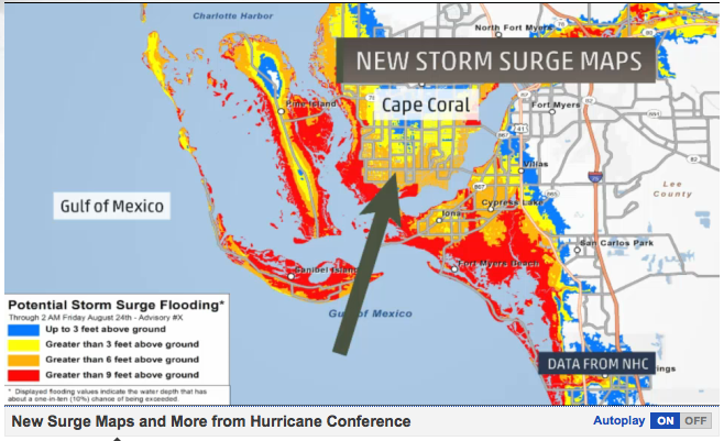
THE NEW NATIONAL HURRICANE CENTER'S MAPS WILL LOOK LIKE STARTING JULY OF THIS YEAR.


NEW NHC POTENTIAL STORM SURGE MAPS:


This will be a new section on the NHC's website (experimental, will be around for at least 2 years), it will be
updated just like the tracks are (every 6/12 hours, as needed) and will be found on NHC starting June 1st.
xoxo disaster girl


P.F.S. Links for the Curious

October 3, 2013

Gulf Threats - Tropical Depression Karen - Updated 10/7 12AM

Tropical Depression Karen

Tropical     Storm     Karen
Max Ssd.  Winds:   30  MPH
Moving: North East at 2 MPH
Min.  Pressure:   1009  MB-
Last Updated: 10/ 07/ 2013
US Land  Impacts:  LA, MS,
AL,  GA,  FL,  - Gulf  Coast

Storm Related Events
-FEMA is doing a "limited recall" of workers in affected areas, over 80% were furloughed in recent government shutdown.
-Mississippi declares State of Emergency in preparation of storm-This storm is expected to make two landfalls, one in Louisiana and another in the Florida Panhandle
-Alabama declares State of Emergency due to likely impact from Karen.
-New Orleans & Louisiana declare State of Emergency ahead of Tropical Storm Karen
-Hurricane watches for coastal cities no longer in effect as of the morning of 10/5.
-Evacuation orders in Louisiana eased as storm loses punch.

All warnings discontinued as Karen dissipates and becomes a remnant low.

xoxo disaster girl

July 8, 2013

Atlantic Tropical Update - Tropical Wave Chantal Moves Over Lesser Antilles - 7/11 AM Update

Tropical Wave Chantal
NOTE: THE ABOVE IMAGE IS FROM 7/9 AND IS NOT NEW
Courtesy of the National Hurricane Center

Tropical     Wave     Chantal
Max Ssd.Winds:  45 MPH↓
Moving: West at 23 MPH↓
Min Pressure: 1012 MB ↑
Last Updated:  7/11/2013

Chantal is currently listed as a tropical wave, I will be keeping an eye on Chantal for possible restrengthening (the storm only slightly weakened, but became very disorganized). Check back tomorrow for more updates!

Major   City   Hit   Timeline
E  Cuba - 7/11  AM / PM
Bahamas -  7/11 PM-AM
SE Florida-7/12 PM-AM
 E Coast FL - 7/12 - 7/14

 Stay tuned!

xoxo disaster girl